Guatemala ENACTS daily rainfall
Guatemala ENACTS daily rainfall: Merged data (Stations from INSIVUMEH + CHIRPS) 1981-2024.
Documents
| outline | an outline showing all sub-datasets and variables contained in this dataset |
\begin{ingrid}
continuedataset:
/description (Merged data (Stations from INSIVUMEH + CHIRPS) 1981-2024) def
grid:
/name (Y)def
/units (degree_north)def
13.52499946 0.05 18.47499953
/long_name (Latitude) def
:grid
grid:
/name (X)def
/units (degree_east)def
-92.4749987 0.05 -88.02499863
/long_name (Longitude) def
:grid
grid:
/name /T def
/standard_name (time) def
/units (julian_day) def
/defaultvalue {last} def
1 Jan 1981 julian_day
1.0
31 Jan 2024 julian_day
:grid
/rfe{
[ X Y | T ] (/local/datalib/data/Guatemala/ENACTS/precip/daily/MERGED_RAIN_Data_1ene1981_31ene2024/rr_mrg_%Y%m%d[T].nc) [T]
readdatafile:
/name (precip) def
/units /mm def
/long_name (Merged Station-Satelite Rainfall 1981-2024) def
/missing_value -99.0 def
/realarraytype netcdfrecords :readdatafile
daily_precip_colors
DATA 0 130 RANGE
}defasvarsilent
:dataset
\end{ingrid}
Independent Variables (Grids)
| Time (time) | grid: /T (julian_day) ordered (1 Jan 1981) to (31 Jan 2024) by 1.0 N= 15736 pts :grid
|
| Longitude (longitude) | grid: /X (degree_east) ordered (92.475W) to (88.025W) by 0.04999997 N= 90 pts :grid
|
| Latitude (latitude) | grid: /Y (degree_north) ordered (13.525N) to (18.475N) by 0.05000001 N= 100 pts :grid
|
Last updated: Thu, 04 Apr 2024 15:36:13 GMT\begin{ingrid}
continuedataset:
/description (Merged data (Stations from INSIVUMEH + CHIRPS) 1981-2024) def
grid:
/name (Y)def
/units (degree_north)def
13.52499946 0.05 18.47499953
/long_name (Latitude) def
:grid
grid:
/name (X)def
/units (degree_east)def
-92.4749987 0.05 -88.02499863
/long_name (Longitude) def
:grid
grid:
/name /T def
/standard_name (time) def
/units (julian_day) def
/defaultvalue {last} def
1 Jan 1981 julian_day
1.0
31 Jan 2024 julian_day
:grid
/rfe{
[ X Y | T ] (/local/datalib/data/Guatemala/ENACTS/precip/daily/MERGED_RAIN_Data_1ene1981_31ene2024/rr_mrg_%Y%m%d[T].nc) [T]
readdatafile:
/name (precip) def
/units /mm def
/long_name (Merged Station-Satelite Rainfall 1981-2024) def
/missing_value -99.0 def
/realarraytype netcdfrecords :readdatafile
daily_precip_colors
DATA 0 130 RANGE
}defasvarsilent
:dataset
\end{ingrid}
\begin{ingrid}
continuedataset:
/description (Merged data (Stations from INSIVUMEH + CHIRPS) 1981-2024) def
grid:
/name (Y)def
/units (degree_north)def
13.52499946 0.05 18.47499953
/long_name (Latitude) def
:grid
grid:
/name (X)def
/units (degree_east)def
-92.4749987 0.05 -88.02499863
/long_name (Longitude) def
:grid
grid:
/name /T def
/standard_name (time) def
/units (julian_day) def
/defaultvalue {last} def
1 Jan 1981 julian_day
1.0
31 Jan 2024 julian_day
:grid
/rfe{
[ X Y | T ] (/local/datalib/data/Guatemala/ENACTS/precip/daily/MERGED_RAIN_Data_1ene1981_31ene2024/rr_mrg_%Y%m%d[T].nc) [T]
readdatafile:
/name (precip) def
/units /mm def
/long_name (Merged Station-Satelite Rainfall 1981-2024) def
/missing_value -99.0 def
/realarraytype netcdfrecords :readdatafile
daily_precip_colors
DATA 0 130 RANGE
}defasvarsilent
:dataset
\end{ingrid}
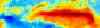 data as colors
 data as contours
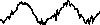 data as line \begin{ingrid}
continuedataset:
/description (Merged data (Stations from INSIVUMEH + CHIRPS) 1981-2024) def
grid:
/name (Y)def
/units (degree_north)def
13.52499946 0.05 18.47499953
/long_name (Latitude) def
:grid
grid:
/name (X)def
/units (degree_east)def
-92.4749987 0.05 -88.02499863
/long_name (Longitude) def
:grid
grid:
/name /T def
/standard_name (time) def
/units (julian_day) def
/defaultvalue {last} def
1 Jan 1981 julian_day
1.0
31 Jan 2024 julian_day
:grid
/rfe{
[ X Y | T ] (/local/datalib/data/Guatemala/ENACTS/precip/daily/MERGED_RAIN_Data_1ene1981_31ene2024/rr_mrg_%Y%m%d[T].nc) [T]
readdatafile:
/name (precip) def
/units /mm def
/long_name (Merged Station-Satelite Rainfall 1981-2024) def
/missing_value -99.0 def
/realarraytype netcdfrecords :readdatafile
daily_precip_colors
DATA 0 130 RANGE
}defasvarsilent
:dataset
\end{ingrid}
\begin{ingrid}
continuedataset:
/description (Merged data (Stations from INSIVUMEH + CHIRPS) 1981-2024) def
grid:
/name (Y)def
/units (degree_north)def
13.52499946 0.05 18.47499953
/long_name (Latitude) def
:grid
grid:
/name (X)def
/units (degree_east)def
-92.4749987 0.05 -88.02499863
/long_name (Longitude) def
:grid
grid:
/name /T def
/standard_name (time) def
/units (julian_day) def
/defaultvalue {last} def
1 Jan 1981 julian_day
1.0
31 Jan 2024 julian_day
:grid
/rfe{
[ X Y | T ] (/local/datalib/data/Guatemala/ENACTS/precip/daily/MERGED_RAIN_Data_1ene1981_31ene2024/rr_mrg_%Y%m%d[T].nc) [T]
readdatafile:
/name (precip) def
/units /mm def
/long_name (Merged Station-Satelite Rainfall 1981-2024) def
/missing_value -99.0 def
/realarraytype netcdfrecords :readdatafile
daily_precip_colors
DATA 0 130 RANGE
}defasvarsilent
:dataset
\end{ingrid}
data as line \begin{ingrid}
continuedataset:
/description (Merged data (Stations from INSIVUMEH + CHIRPS) 1981-2024) def
grid:
/name (Y)def
/units (degree_north)def
13.52499946 0.05 18.47499953
/long_name (Latitude) def
:grid
grid:
/name (X)def
/units (degree_east)def
-92.4749987 0.05 -88.02499863
/long_name (Longitude) def
:grid
grid:
/name /T def
/standard_name (time) def
/units (julian_day) def
/defaultvalue {last} def
1 Jan 1981 julian_day
1.0
31 Jan 2024 julian_day
:grid
/rfe{
[ X Y | T ] (/local/datalib/data/Guatemala/ENACTS/precip/daily/MERGED_RAIN_Data_1ene1981_31ene2024/rr_mrg_%Y%m%d[T].nc) [T]
readdatafile:
/name (precip) def
/units /mm def
/long_name (Merged Station-Satelite Rainfall 1981-2024) def
/missing_value -99.0 def
/realarraytype netcdfrecords :readdatafile
daily_precip_colors
DATA 0 130 RANGE
}defasvarsilent
:dataset
\end{ingrid}
\begin{ingrid}
continuedataset:
/description (Merged data (Stations from INSIVUMEH + CHIRPS) 1981-2024) def
grid:
/name (Y)def
/units (degree_north)def
13.52499946 0.05 18.47499953
/long_name (Latitude) def
:grid
grid:
/name (X)def
/units (degree_east)def
-92.4749987 0.05 -88.02499863
/long_name (Longitude) def
:grid
grid:
/name /T def
/standard_name (time) def
/units (julian_day) def
/defaultvalue {last} def
1 Jan 1981 julian_day
1.0
31 Jan 2024 julian_day
:grid
/rfe{
[ X Y | T ] (/local/datalib/data/Guatemala/ENACTS/precip/daily/MERGED_RAIN_Data_1ene1981_31ene2024/rr_mrg_%Y%m%d[T].nc) [T]
readdatafile:
/name (precip) def
/units /mm def
/long_name (Merged Station-Satelite Rainfall 1981-2024) def
/missing_value -99.0 def
/realarraytype netcdfrecords :readdatafile
daily_precip_colors
DATA 0 130 RANGE
}defasvarsilent
:dataset
\end{ingrid}